


Active Topics
-
Is there a section to talk about Java ME? Apps, etc. (3)
to General by Kalatti - 23 hrs, 32 mins ago - more...

| The Following 16 Users Say Thank You to rinigus For This Useful Post: | ||
Amboss, eson, Fellfrosch, imaginaryenemy, jayki, Jordi, juiceme, klinglerware, lal, MartinK, nthn, olf, pagis, PamNor, peterleinchen, taixzo | ||
 |

|
2019-02-02
, 15:09
|
|
Posts: 1,092 |
Thanked: 4,995 times |
Joined on Dec 2009
@ beautiful cave
|
#393
|
@rinigus Thanx for your continuing development and this fantastic app!!!!!
To make it even better, I want to tell you about two things which are not perfect yet:
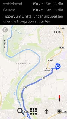
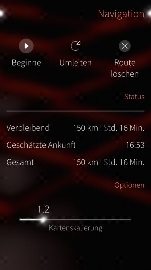
At first just a small issue, which is maybe not visible in other languages, but in German. In portrait view you can't see the complete time the journey takes, even so there is enough space on the left side.
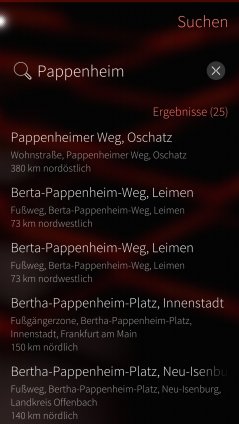
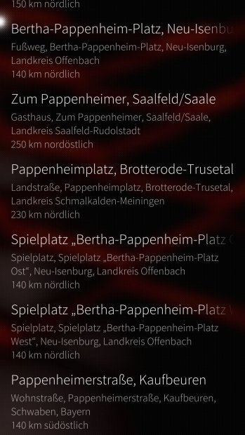
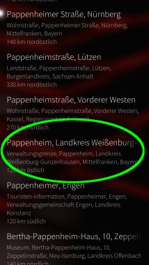
Second problem, is still the search function. I use OSM Scout Server for search with default settings. If I search for Pappenheim, there are a lot of entries listed before the relevant search result.
I would expect the city of Pappenheim is listed above Pappenheimer Weg in Oschatz or Berta-Pappenheim-Weg in Leimen. I attached some screenshots of the search result. The City I searched for is on rank 18.
...
To make it even better, I want to tell you about two things which are not perfect yet:
At first just a small issue, which is maybe not visible in other languages, but in German. In portrait view you can't see the complete time the journey takes, even so there is enough space on the left side.
Second problem, is still the search function. I use OSM Scout Server for search with default settings. If I search for Pappenheim, there are a lot of entries listed before the relevant search result.
I would expect the city of Pappenheim is listed above Pappenheimer Weg in Oschatz or Berta-Pappenheim-Weg in Leimen. I attached some screenshots of the search result. The City I searched for is on rank 18.
...
| The Following 8 Users Say Thank You to Fellfrosch For This Useful Post: | ||
|
|
2019-02-02
, 16:15
|
|
Posts: 1,414 |
Thanked: 7,547 times |
Joined on Aug 2016
@ Estonia
|
#394
|
@Fellfrosch, when you search for Pappenheim at https://www.openstreetmap.org/search?query=Pappenheim , is the one that you are interested in the first one? Can you provide me a link at OSM like https://www.openstreetmap.org/relation/1015139 for the corresponding town?
Re space issue - I'll try to get the best I can for it ASAP
Re space issue - I'll try to get the best I can for it ASAP
| The Following 4 Users Say Thank You to rinigus For This Useful Post: | ||
|
|
2019-02-02
, 17:29
|
|
Posts: 1,092 |
Thanked: 4,995 times |
Joined on Dec 2009
@ beautiful cave
|
#395
|
@rinigus yes, if I use openstreetmap for search, the first result is the correct one and therefore the link you provided is already the right one.
|
|
2019-02-03
, 11:31
|
|
Posts: 1,414 |
Thanked: 7,547 times |
Joined on Aug 2016
@ Estonia
|
#396
|
@Fellfrosch, Pappenheim was sorted so down in the list due to the preference to the objects which have less levels in their full name. When looking at search strings, you could see the number of levels through the number of commas in the string. Obviously, this doesn't work that well.
Issue filed https://github.com/rinigus/geocoder-nlp/issues/58
The issue with too long strings in Pure Maps navigation overview is resolved now and will be available with the next release
Issue filed https://github.com/rinigus/geocoder-nlp/issues/58
The issue with too long strings in Pure Maps navigation overview is resolved now and will be available with the next release
| The Following 5 Users Say Thank You to rinigus For This Useful Post: | ||
 |
|
2019-02-03
, 11:54
|
|
Posts: 4,117 |
Thanked: 8,901 times |
Joined on Aug 2010
@ Ruhrgebiet, Germany
|
#397
|
@rinigus
Thanks for that wonderful piece of SW (same applies to otsaloma) and the continuing support. (needed to be said! )
)
As I got a car navigation system now I use PureMaps more seldom.
But even when I used it I could not remember best sorting of search parameters.
Afair we should use national order (so for Germany: street, zip, city, country) or was it international order -what I would prefer- going down from universe, milky way to street number.
Do we need (or must we not) separate with commata?
Something I mixed and got bad results earlier. And now I forgot already
What about a small reminder in settings or info or search page or ...?
Thanks for that wonderful piece of SW (same applies to otsaloma) and the continuing support. (needed to be said!
)As I got a car navigation system now I use PureMaps more seldom.
But even when I used it I could not remember best sorting of search parameters.
Afair we should use national order (so for Germany: street, zip, city, country) or was it international order -what I would prefer- going down from universe, milky way to street number.
Do we need (or must we not) separate with commata?
Something I mixed and got bad results earlier. And now I forgot already
What about a small reminder in settings or info or search page or ...?
__________________
SIM-Switcher, automated SIM switching with a Double (Dual) SIM adapter
--
Thank you all for voting me into the Community Council 2014-2016!
Please consider your membership / supporting Maemo e.V. and help to spread this by following/copying this link to your TMO signature:
[MC eV] Maemo Community eV membership application, http://talk.maemo.org/showthread.php?t=94257
editsignature, http://talk.maemo.org/profile.php?do=editsignature
|
|
2019-02-03
, 12:07
|
|
Posts: 1,414 |
Thanked: 7,547 times |
Joined on Aug 2016
@ Estonia
|
#398
|
When using OSM Scout Server, its either natural for your country/language (should be parsed by libpostal) or from street number to milky way. See Parsers in https://rinigus.github.io/osmscout-server/en/
The online services, I assume, have their own preference.
I will get one day to work on geocoder of OSM Scout Server and will then look into improving the situation. That's the largest weakness, I think, in OSM Scout Server currently.
Edit: corrected the order, sorry for mixing up.
Last edited by rinigus; 2019-02-03 at 12:22.
| The Following 7 Users Say Thank You to rinigus For This Useful Post: | ||
|
|
2019-02-03
, 12:26
|
|
Posts: 1,203 |
Thanked: 3,027 times |
Joined on Dec 2010
|
#399
|
Seeing your discussion on drive icon, if road markings, cars, arrows in the middle etc are too specific, why not just a curvy road with no road markings. It's then not tied to any particular form of transport, it's just the path you take.
| The Following 6 Users Say Thank You to Android_808 For This Useful Post: | ||
 |
|
2019-02-03
, 21:18
|
|
Posts: 304 |
Thanked: 1,246 times |
Joined on Aug 2015
|
#400
|
Originally Posted by peterleinchen

I looked up some addresses in Berlin today, in the German national format <street name> <house number>, <post code> Berlin, which all worked fine.
[...]
Afair we should use national order (so for Germany: street, zip, city, country) or was it international order -what I would prefer- going down from universe, milky way to street number.
Do we need (or must we not) separate with commata?
Something I mixed and got bad results earlier. And now I forgot already
Can you please retest and name specific examples, which do not work for you.
| The Following 6 Users Say Thank You to olf For This Useful Post: | ||
This release brings a map view that can either show all defined buttons/widgets (full view) or a selected set of them (minimal view). To switch between the modes, just click on a map avoiding bookmarked places and current location.
Buttons and indicators shown in the minimal view mode can be selected in Preferences/Map View. You could also specify whether you want application to go to the minimal view mode automatically and/or use that on startup.
There are direct Search and Navigate buttons on the map view. The icons for the both buttons are considered as not final, replacement is expected in the future. So, as a result, you get now the same amount of clicks as in Google Maps/HERE to start searching, for example.
All action buttons on the map view are now positioned at the button. This should simplify its use on mobile.
Position icon has been replaced with a high contrast version, thank you Mosen!
Translations have been updated, thank you translators!
I have spent a large time on this update cycle on porting the application to Kirigami. This is going to bring full mobile support for other mobile Linux'es as well as convergence support. The latter one turned out to be tricky, had to rewrite few parts which were assuming that only one page is shown in a time. Also, there were few assumptions that I made regarding Kirigami API and had to figure mistakes out/fix them for that port. Finally, Kirigami had/has few bugs that were uncovered while working on it. Fortunately, some of them are fixed already and Pure Maps requirements are taken into account by Kirigami developers during their ongoing rewrite of the main component. Hopefully, Kirigami will be the platform for the next release on Flathub.
Edit: New Mapbox key was generated for general usage. Let's see if the main users have made sufficient amount of keys to keep overall usage within the limits
Last edited by rinigus; 2019-02-02 at 10:04.